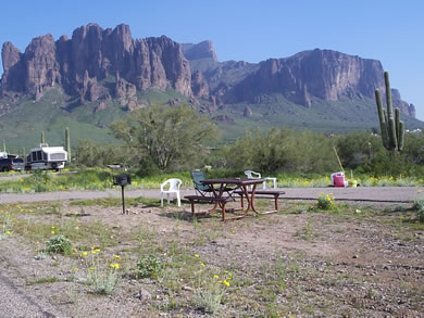
Above:
Lost Dutchman State Park at the base of the Superstition
Mountains.
During
the 1840's, the Peralta family of northern Mexico supposedly
developed a rich gold mine in the Superstitions. According
to legend, an Apache ambush ended the family's last expedition,
and the gold remained in the area. In the 1870's, Jacob Waltz
("the Dutchman") was said to have located the mine
through the aid of the Peralta descendant. Waltz and his partner,
Jacob Weiser, worked in the mine and allegedly hid one or
more caches of gold in the Superstitions. Most stories place
the gold in the vicinity of Weaver's Needle.
After
Waltz's death in 1891, several people attempted to seek
out the Lost Dutchman's Mine, all without luck. Later searchers
have sometimes met with foul play or even death, contributing
to the superstition and legend of these mountains.
The
legend of the "lost mine" has been fueled by a
number of people who were supposed to have known the mine's
location or even worked it. Maps have surfaced over the
years, only to become lost or misplaced.
Trails
Please use caution when hiking at the park. Those planning
to use the longer trails should carry a topographic map. Each
person should carry at least one gallon of drinking water
per day. Remember summer temperatures often exceed 100°F.
Treasure Loop Trail: Length 2.4 miles round
trip, rated moderate, elevation change of 500 feet. It terminates
at either picnic area.
Prospector's
View Trail: Length 0.7 miles, rated moderate. It
connects Siphon Draw Trail with Treasure Loop Trail also
connects with Jacob's Crosscut Trail.
Jacob's
Crosscut Trail: Trail runs 0.8 miles along the
base of the mountain, rated easy. It connects Treasure Loop
Trail with Prospector's View Trail, and continues 4.5 miles
past the park area along the base of the Superstitions.
Siphon
Draw Trail: 3.2 miles round trip, a very scenic
hike, this trail winds up into a canyon known as Siphon
Draw. It is possible to hike up the Flatiron, although it
is not a designated, maintained trail all the way. It's
advised that only experienced hikers in good shape attempt
to hike to the top, as the climb is steep and difficult
to follow. Allow at least five hours to the Flatiron and
back.
Discovery
Trail: Connects the campground and day use areas.
Features information signs, a wildlife pond, bird feeder
and viewing bench.
Group-Use Facilities
Facilities:
Group camping area, group picnic ramada.
Amenities:
Ramadas, tables, water, fire pit, grills, electric (group
picnic area Ramada).
Maximum
Group Size: Camping area – 150 people, picnic
area – 100 people.
Picnic
Areas: Yes (3).
Reservation
Policy: $25 for picnic ramada, $25 for camping
area. +$5.00 reservation fee
Restrictions:
General park rules and regulations.
Hours:
Sunrise to 10pm, Renew by 11am,. 12pm check out for campers.
Group
Use Fees: Fees apply. Please call for current fees.
Contact
Name and Phone Number: Park Staff – (480)
982-4485.
Rules and Regulations
No ground fires (fires ok in established fire pits) or wood collecting in park.
Damage or removal of natural rocks, vegetation, or public
property is prohibited.
Keep pets on leash.
Obey all firearm regulations.
Prevent loud nuisance noises.
Vehicle with tow vehicle is considered one unit, maximum 12 people. $15 per extra vehicle. Call 480-982-4485 for details.
Camping permitted in designated sites only.
There is a 15 day stay limit for campground.
Checkout time is 12:00 p.m.
Quiet hours are 9:00 p.m. to 8:00 a.m.
Nearby Attractions
Boyce Thompson Arboretum State Park, Superstition Mountains,
Tonto National Forest, Apache Trail, and Apache, Canyon,
Saguaro & Roosevelt Lakes.
Directions
The
park is located 5 mi. north of Apache Junction, off of
AZ 88 (the old Apache Trail), at the base of the Superstition
Mountains.