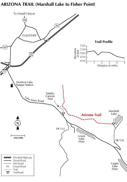
Plentiful wildlife and great views of the San Francisco Peaks provide the major features of interest on this section of the state-spanning Arizona Trail. For the best views, begin at the Marshall Lake Trailhead. This vital wetland, which is more of a marsh than a lake, is frequented by bald eagles in winter and osprey in summer. Waterfowl and a variety of smaller hawks are generally present year-round. The bulk of the trail winds across Anderson Mesa, a broad grassy upland dotted with widely spaced trees. The open character of the terrain here provides excellent opportunities to view the area's wildlife residents. Anderson Mesa supports a rich and diverse community of wild animals some of the larger and more visible are elk, mule deer, whitetail deer, wild turkey, Abert's squirrels, coyotes, and pronghorn antelope. As you near Fisher Point and drop into Walnut Canyon, have your camera ready for some of the most photogenic views of the San Francisco Peaks available anywhere on the Forest. There are even some red rock cliffs here that are reminiscent of Oak Creek and the Grand Canyon. General Notes: Rating: Moderate Hiking time: 2 hours Notes:
Directions: USGS Map: Flagstaff East Location: 12 miles (about 30 minutes) southeast of Flagstaff on paved and graveled Forest Roads. Access: Best access to the Fisher Point end of the trail is via Sandy's Canyon Trailhead. Drive southeast out of Flagstaff 6 miles on Lake Mary Road (Forest Highway 3). Just past the second cattle guard turn north (left) to the trailhead. Marshall Lake Trailhead: Continue past Sandy's Canyon turnoff 9.2 miles to the FR 128 intersection. Turn left on FR 128 and drive 2.2 miles to the Marshall Lake trailhead.
|
|||||||||||||||||||||||||||||||||||||
All original material and HTML coding © 2004-2021 camparizona.com |
|||||||||||||||||||||||||||||||||||||