Griffith’s Spring is a shaded and peaceful one-mile loop trail that is close to Flagstaff and is an excellent example of a riparian habitat. James Griffith was a Civil War veteran that came west to homestead in the late 1800’s. The spring was part of the homestead which consisted of over 160 acres of diverse countryside.
Following the trail to the right at the beginning of the loop, you’ll walk through a Ponderosa pine forest on a wide, well-maintained path. The trail follows a small canyon to a tank that forms a stream in late summer months after heavy rains. Near the stream you may see wild iris, lupine and hear western bluebirds, robins and hummingbirds. Continuing on up the trail a short distance you’ll find Griffith’s Spring. This spring runs into Pump House Wash, then eventually into Oak Creek. There is a board crossing the spring, but you will turn around and rejoin the trail going to the right to complete the loop.
At a Glance
Usage:
Light
Best Season:
April - October, depending on funding (Call first to determine trail is open)
Closest Towns:
Flagstaff, AZ
Water:
No
Restroom:
Vault Toilet (1)
Operated By:
Flagstaff Ranger District - 928-526-0866
General Information
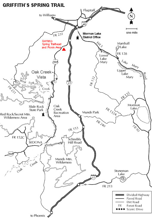
Directions:
Location: Drive south on 89A approximately 2 miles past the Flagstaff Airport exit and Fort Tuthill. The Griffith Springs day-use area is signed appropriately and will be on the left (east) side of Highway 89A.
GPS: N35° 6' 54.7554", W-111° 42' 42.696"
General Notes:
Area/Length : 1 mile loop
Latitude : 35.115220
Longitude : -111.711847
Elevation : 6948'
Rating: very easy
Season: April through October, depending on funding (Please call the District Office prior to going to make sure trailhead is open)
USGS Map: Mountainaire Quad
Facilities: Picnic table, Vault-type toilet
Notes:
No motorized vehicles
The trail that follows the stream is a dead end. Do not pass through the culvert at the road or go into the adjacent community.
No garbage services; "Pack-it-in, Pack-it-out"
Leave No Trace: Please help the Forest Service protect the land by following these principles: 1) Plan ahead and prepare, 2) Travel and camp on durable surfaces, 3) Dispose of waste properly, 4) Leave what you find, 5) Minimize campfire impacts, 6) Respect wildlife, 7) Be considerate of other visitors.