The San Francisco Peaks are actually the remains of an extinct volcano. Millions of years ago this great mountain was shattered by an explosion similar to the one that devastated Washington's Mt. Saint Helens in 1980. Inside the now quiet caldera a lush alpine environment has blurred evidence of that cataclysmic event.
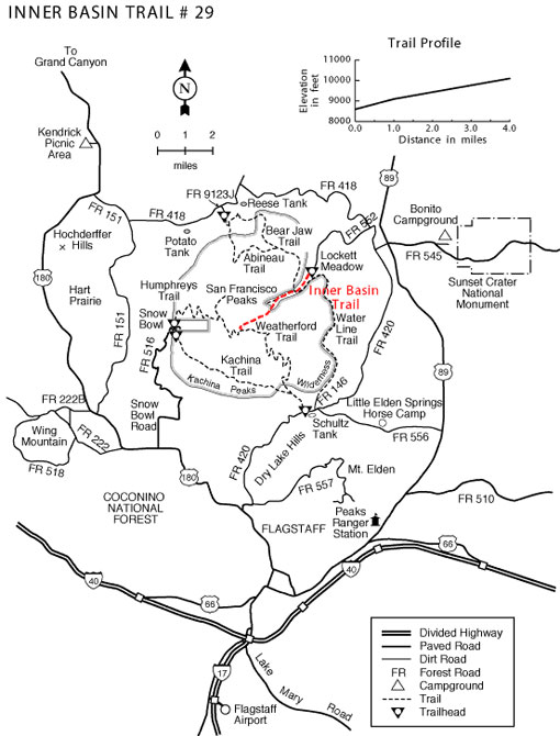
The trail into the heart of the ancient volcano begins in beautiful Lockett Meadow. From this island of emerald ringed with aspens and high peaks it follows a primitive road into the mountain's now quiet Inner Basin and then connects to the Weatherford trail. Here, extensive stands of aspens cover the steep slopes of the old caldera coloring them solid gold in early fall. In spring and summer, wildflowers add a sprinkling of blue, red and yellow. From the basin's rims, avalanche tracks streak down the talus slopes and remnants of old lava flows bear witness to the mountain's cataclysmic heritage.
Snow may remain here even into summer. Cross-country skiers continue to ski as late as June in some years. Hiking is the most popular way of visiting this beautiful and unique environment; however, and hikers begin coming to the basin before the snows have completely melted from the trail.
Animals you may see in this high country include porcupine and elk. Black bears have been known to stroll right through groups of picnickers without so much as a glance at their lunches. The hermit thrush sings his best here. The climb to this high mountain place, where spring comes late and fall arrives early, is moderate but steady, but the reward is worth every bit of the effort.
There is no camping allowed in the Inner Basin. There is a special order closing the Inner Basin/Flagstaff Municipal Watershed to camping, horse use, pets, etc. [See Forest Order 04-149]
Closest Towns:
Flagstaff, AZ
Operated By:
Flagstaff Ranger District - 928-526-0866
General Information
Directions:
USGS Map: Humphreys Peak
Location: 15 miles north of Flagstaff on paved and dirt Forest Roads.
GPS: N35° 21' 26.2434", W-111° 37' 19.6314"
Access: Drive northeast of Flagstaff on US 89 for 12 miles to FR 420 directly across from the Sunset Crater turnoff. Turn left (west) for about 1/2 mile, turn right (north) on Forest Road 552. Turn right at the Lockett Meadow sign and continue to the trailhead. This road is closed in early spring and late fall due to snow.
General Notes:
Rating: Moderate
Area/Length : 3.9 miles
Latitude : 35.356876
Longitude : -111.622896
Elevation : 8610'
Notes:
No mechanized or motorized vehicles, including bicycles, in Wilderness Area.
No camping in the inner basin in order to protect the watershed.
The inner basin is closed to dogs and livestock above the watershed cabin.