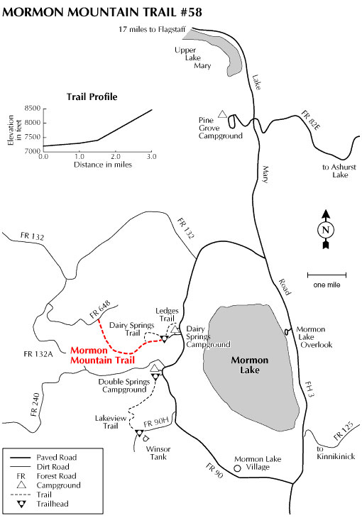
This trail to the top of 8,449 foot Mormon Mountain climbs gradually through a forest of ponderosa pine, mixed conifers, and aspen. At a number of places along the route openings in the forest canopy provide long distance views of Mormon Lake (see notes below) and the grassy flats and forest-covered hills that surround it.
The trail begins at the rear of the group-camp area of Dairy Springs Campground, which is located just west of the road that borders Mormon Lake's eastern shore. For a short distance after leaving the trailhead, Mormon Mountain Trail shares the path with the self-guided nature trail that skirts the campground. The mountain trail then branches off on its own to complete the 1,500 foot climb. As the trail nears the top of Mormon Mountain it joins a primitive road (FR 648) which leads to the summit and good views of Mormon Lake and the San Francisco Peaks.
At a Glance
Usage:
Medium
Best Season:
April thru November
Closest Towns:
Mormon Lake, AZ, Flagstaff, AZ
Operated By:
Flagstaff Ranger District - 928-526-0866
General Information
Directions:
USGS Maps: Mormon Lake, Mormon Mtn.
Location: About 24 miles southeast of Flagstaff just north of Mormon Lake.
Access: Drive south 20 miles from Flagstaff on Forest Highway 3 (Lake Mary Road) to the Forest Road 90 intersection. Turn west on FR 90 and drive 3.5 miles to the Montezuma Lodge turnoff. Drive 0.6 miles to the trailhead. All roads are paved except the last 0.6 miles.
General Notes:
Rating: Moderate
Area/Length : 3.0 miles
Latitude : 34.955633
Longitude : -111.489157
Elevation : 7237
Notes:
No motorized vehicles.
Mormon Lake often dries up (to become "Mormon Meadow") during drought conditions!