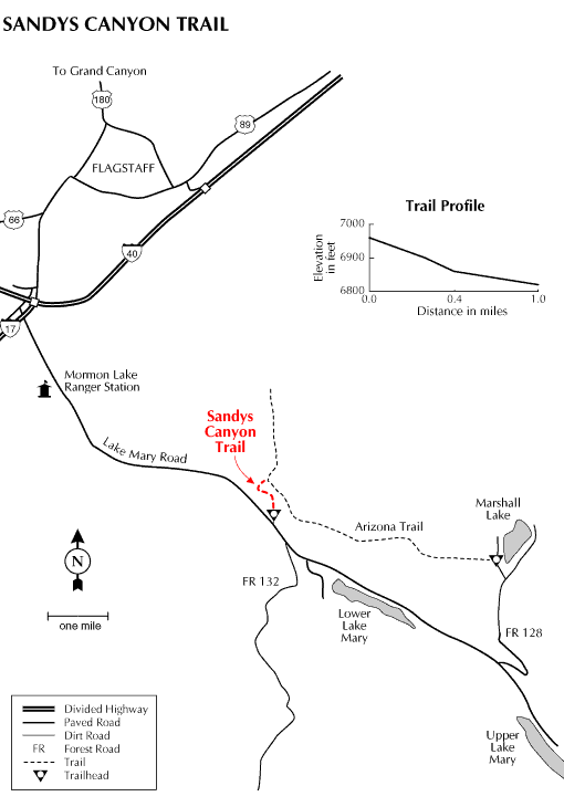
Here's a trail just a few minutes outside Flagstaff that offers good photo opportunities, interesting geology, great views, and access to a longer trail that stretches all the way across Arizona. Sandys Canyon Trail starts out by skirting the rim of Walnut Canyon, a scenic rift in the same layers of rock that form the upper cliffs of the Grand Canyon. From the trailhead, you get a great view of the San Francisco Peaks with the cliffs of Walnut Canyon in the foreground - time to reach for the camera
The trail heads north from the trailhead following the Walnut Canyon Rim for a short distance before it drops down Sandys Canyon into the main gorge. Sandys Canyon Trail then continues along the Walnut Canyon floor on an old jeep track to an intersection with the Arizona Trail. Here you'll find more Grand Canyon style cliffs complete with the same bright colors of that World Heritage Site. The pronounced cross-bedding and deep red hue of these petrified Permian Age sand dunes will have you reaching for your camera again.
This trail is best suited for hiking or horsebacking. If you don't have your own steed, a nearby concessionaire provides guided rides into these scenic canyonlands. If you'd like to turn your Sandys Canyon venture into a longer hike you can follow the Arizona Trail either north, down canyon to Fisher Point or east along Walnut toward Marshall Lake. (See the Arizona Trail Marshall Lake to Fisher Point section of this guide.)
At a Glance
Usage:
Medium
Best Season:
April thru November
Closest Towns:
Flagstaff, AZ
Operated By:
Flagstaff Ranger District - 928-526-0866
General Information
Directions:
USGS Maps: Lower Lake Mary, Flagstaff East
Location: Just south of Flagstaff near Lower Lake Mary on paved forest roads.
Access: Drive southeast out of Flagstaff 6 miles on Lake Mary Road (Forest Highway 3). Take the road into Canyon Vista Campground on left going south.
General Notes:
Rating: Easy
Hiking Time: 1 hour round trip.
Area/Length : 1.0 mile
Latitude : 35.127052
Longitude : -111.59793
Elevation : 6832
Notes:
No motor vehicles.
This trail joins the Fisher Point to Marshall Lake section of the Arizona Trail.