Schultz Creek Trail parallels one of several intermittent drainages that carry water from the higher reaches of the San Francisco Peaks. Generally the stream only has water in it a few months of every year, either during the spring snow melt or after a summer monsoon. However, even when there is no water here, which is most of the time, walking beside the water-smoothed stones and ledges worn by ephemeral waterfalls can still give one the pleasant feeling of being near a brook even if you have to imagine the babble
This trail has one of the most moderate gradients on any in the San Francisco Peaks/ Mt. Elden area. Still, it has enough ups and downs to be extremely popular with mountain bikers. So, if you come for a hike or a horseback ride, keep your ears and eyes open and be ready to share the trail with other users.
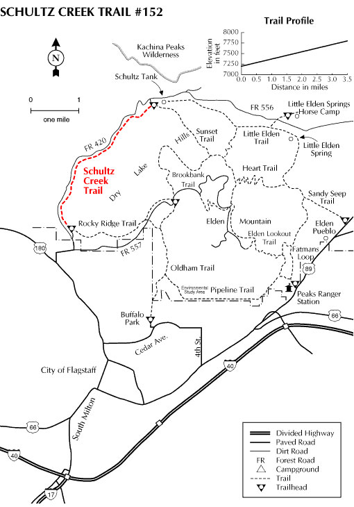
If you hike this trail during a quiet time, Abert's squirrels and Steller's jays are animals you might see here. During late spring and early summer this is a good place to hear the musical trill of the hermit thrush. Schultz Creek Trail serves as a connecting trail between Rocky Ridge and the Sunset trails.
At a Glance
Usage:
Medium-Heavy
Best Season:
April thru November
Closest Towns:
Flagstaff, AZ
Operated By:
Flagstaff Ranger District - 928-526-0866
General Information
Directions:
USGS Maps: Humphreys Peak, Flagstaff West
Location: 3 miles north of Flagstaff off US 180
GPS: N35° 14' 37.6434", W-111° 39' 41.364"
Access: Drive north from Flagstaff 2 miles on US 180 to FR 420 (Schultz Pass Road). Turn east and follow FR 420 about a mile to a gate and cattle guard. Turn right down over the hill toward Schultz Creek and park. The trailhead is at the north end of the parking area.
General Notes:
Rating: Easy
Hiking time: 2 hours
Area/Length : 3.5 miles
Latitude : 35.244606
Longitude : -111.661781
Elevation : 7215 - 7800
Notes:
Please remember that you share the trail with other users and that trail courtesy and safety is your responsibility. Hikers and mountain bikers should yield the trail to equestrians. Mountain bikers should yield the trail to hikers.