There is a hiking trail on the north side of Strawberry Crater. Although numerous paths lead into the area, no additional designated trails have been established.
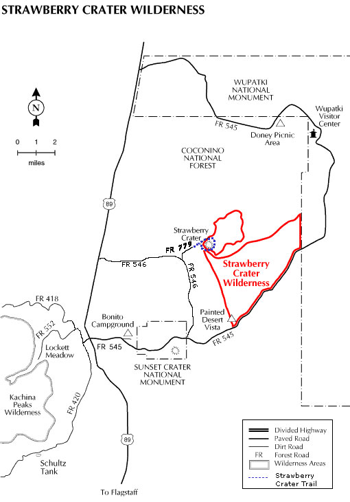
A volcanic cinder cone and lava flow form the centerpiece of this 10,141 acre wilderness. Though the area last erupted around the time that knighthood was about to flower in Europe, the volcanic features you'll see here look as if they had happened much more recently. Molten rock frozen in time still shows scrape marks left as it squeezed up through cracks in the cooler surface.
Petrified bubbles of once boiling stone look as fresh as the sparse vegetation that struggles for a foothold on this rugged moonscape.
Plentiful ruins scattered across this inhospitable landscape prove the resourcefulness of an ancient people who lived here even as the land still fumed and spouted. In places you can also see remnants of the gardens they cultivated using volcanic cinders as a water-retaining mulch. On the horizon, the San Francisco Peaks, Sunset Crater, and the Painted Desert add another dimension to the view.
At a Glance
Open Season:
Year 'round
Usage:
Light
Closest Towns:
Flagstaff, AZ
General Information
Directions:
Location: 20 miles north of Flagstaff off paved and dirt roads
USGS Map: Strawberry Crater Quad
Access: Sunset Crater/Wupatki Road (FR 545) borders one side of the Wilderness. Additional access is provided by FR's 546 and 779 off US 89 at the bottom of the north slope to the pass between the San Francisco Peaks and O'Leary Peak.