Arizona's Best Swimming Holes  


Sycamore Canyon Wilderness Trail System

Upload GPS Tracks
Upload Trail Photos
Trail Ratings
Overall Trail Rating
1 = Poor 5 = Outstanding

Scenic Views
 
Route Finding
1 = Poor 5 = Excellent
 
Technical Difficulty
1 = Easy 5 = Very Difficult
 
Trail Access
1 = Easy 5 = Hard to get to
 

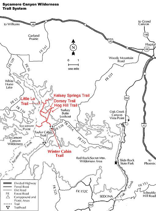
The Sycamore Canyon Wilderness Trail System within the Peaks Ranger District consists of 5 trails with a combined mileage of 11.3 miles with the longest trail being 5.6 miles. These trails include: Kelsey Springs Trail, Dorsey Trail, Winter Cabin Trail, Little Lo Trail, and Hog Hill Trail. Each trail is suitable for day hikes or longer overnight loop hikes.

Sycamore Canyon can be very hot and dry during the summer months. There are several springs located near the Wilderness trails which normally have water year round but hikers should not depend on this water being available and all ground water should always be treated or filtered. There is plenty of shade along all of the trails as you descend into Sycamore Canyon through a thick forest of Ponderosa Pine, Gambel Oak, and Juniper trees. The lower part of Winter Cabin Trail and part of Kelsey Springs Trail takes you through chaparral type vegetation which offers spectacular views of Sycamore Canyon.

Sycamore Canyon is the second largest canyon is Arizona and offers hikers plenty of solitude and natural beauty.

At a Glance

Usage: Light
Best Season: May thru November
Closest Towns: Flagstaff, AZ
Operated By: Flagstaff Ranger District - 928-526-0866
Information Center: List and description of Sycamore Canyon Trails on the Flagstaff District

General Information

Directions:

Location: Southwest of Flagstaff, Arizona

USGS Map: Sycamore Point

Wilderness Map: Sycamore Canyon Wilderness map, 2002 available from local Forest Service Offices

Access: Access to the trailheads is by dirt roads which can be extremely rough and even impassable during Monsoon Season and winter months due to mud and heavy snow.

General Notes:

Rating: Mostly moderate with a few short strenuous sections

Notes:

  • No mechanized vehicles including bicycles in Wilderness.
  • Fire danger is usually high - be careful with campfires.
  • Camp at least 200 feet from springs and bury human waste 200 feet from springs - pack out all trash.

Sycamore Canyon Wilderness Trail System


Comments

comments powered by Disqus


Camping Regions
Camping Regions

Central Arizona
Flagstaff / Sedona / Prescott
Northeast / Grand Canyon
Payson / Mogollon Rim
Southeast / Tucson
White Mountains
Western Arizona


Camping
Resources

Camping Checklist
Camping Gear
Our You Tube Videos
Camping Recipies

Arizona Game and Fish Department

Fishing Reports
Lake Levels
Stocking Schedule
AZ Fishing Rules & Regulations
Where to Fish
Sport Fish Species
Urban Fishing

U.S. Forest Service
National Forests in Arizona

Apache Sitgreaves N.F.
Coconino N.F.
Coronado N.F.
Kaibab N.F.
Prescott N.F.
Tonto N.F.


Site Map
Advertising Information
Contact Us
Links


All campground rates and information are subject to change without notice.


Home | Campgrounds | Hiking Info |Camping Checklist | Fire Information
Western Arizona RV Parks | Fishing Reports | Contact Us | Links
Site Map

All original material and HTML coding © 2004-2021 camparizona.com

Terms of Service | Privacy Policy


Arizona Game and Fish Department U.S. Forest Service