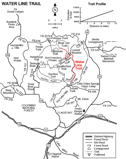
The Water Line Trail begins at the heart of Schultz Pass, traverses the northeast slope of the San Francisco Peaks into the Inner Basin and then continues north and northwest to Abineau Canyon. The views include the volcanic fields east of Flagstaff, Sunset Crater, the Painted Desert and the Grand Canyon ninety miles away. This old road (also known as the Watershed Road) runs along the base of a long talus slope topped by Arizona's highest point, Humphreys Peak. The southern portion of the road borders the Kachina Peaks Wilderness and from the Inner Basin to the Abineau Trail both sides of the road are Wilderness. Remember no mechanized vehicles, including Mountain Bikes, are allowed in Wilderness.
There is a chance you may see sign of the shy Black bear here. Elk and mule deer are abundant in this area. Common bird species you may see include: Dark-eyed junco, Stellar Jay and Clark's nutcracker.
At a Glance
Usage:
Heavy
Best Season:
May thru November
Closest Towns:
Flagstaff, AZ
Operated By:
Flagstaff Ranger District - 928-526-0866
General Information
Directions:
Location: 6 miles north of Flagstaff on graveled forest roads
USGS Map: Humphreys Peak
Access: Drive 2 miles northeast of Flagstaff on US 180 to FR 420 (Schultz Pass Road). Turn left (stay on FR 420) at the FR 557 intersection. Continue on FR 420 for 6.5 miles to FR 146. Turn left and follow to the end of the road. Parking here is limited, additional parking is available at Schultz Tank. Equestrians should park at the Sunset Trailhead.
General Notes:
Rating: Easy
Hiking time: 6 hours (one way)
Area/Length : 14 miles
Latitude : 35.287378
Longitude : -111.624051
Elevation : 10400 - 8020
Notes:
Use Caution! This road is often travelled by Flagsaff City vehicles and during fires or other emergencies, US Forest Service vehicles.
Motorized and mechanical vehicles and equipment, including mountain bikes, are not permitted in Wilderness.
An equestrian water source is available at Schultz Tank.