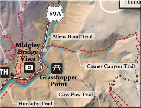
The trail begins on the south-east side of the recreation area parking lot at Grasshopper Point. The trailhead sign is at the kiosk near the covered picnic table.
The trail is near level and mostly in full shade from remnants of an old orchard and various native riparian trees. It follows along the foot of a rock wall on the left, a short distance from Oak Creek which can be heard but is seldom in sight.
Several short paths provide access to this scenic creek for fishing, swimming, and picnicking. Be careful of poison ivy. The trail ends at the Casner Canyon Trailhead. Return by the same route for a pleasant 1 mile hike. The trail is probably named for Charles R. Allen, a photographer who homesteaded at the location of the present Junipine Cabins further upstream.
Notes: No motor vehicles. This trail can be hot and dry in summer.
USGS Maps: Munds Park
At a Glance
Open Season:
Year 'round
Usage:
Medium-Heavy
Best Season:
Summer
Busiest Season:
Summer
Operated By:
Red Rock Ranger District - 928-203-2900
General Information
Directions:
Location: 25 miles south of Flagstaff (2 miles north of Sedona) on paved roads in scenic Oak Creek Canyon. Elevation is 4400 feet at the trailhead.
From the junction of Routes 89A and 179 (the "Y") in Sedona, take 89A north 2.5 miles to Grasshopper Point on the right (milepost 376.7). Drive down to the recreation area parking lot (you'll pay a fee here) or park in a roadside turnout 1/2 miles north of Grashopper Point and walk down the access road (.2 miles) the the north end of Allens Bend Trail.