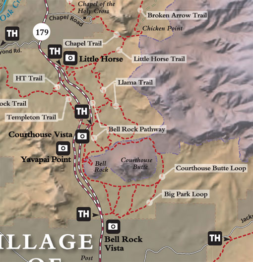
The Bell Rock Pathway is a 3.6 mile trail. Along this pathway you'll enjoy fantastic views of Bell Rock, Courthouse Butte, and other landmarks. Most of the pathway has a wide, hard surface, but there are some steep hills too. Some places around Bell Rock are rocky and rough.
The Bell Rock Vista has accessible restrooms (vault-type toilets), paved parking and covered kiosks.
Rating: Easy to Moderate
Hiking Time: Allow 2.5 hours
Notes:
Horses are prohibited on Bell Rock Pathway.
The Pathway passes very close to Munds Mountain Wilderness. Please keep Wilderness "wild" for future visitors, leave no evidence of your visit.
Cyclists: Please control your speed at all times and be prepared to stop quickly. Expect to find someone on the trail around every corner. Remember, it is the cyclist's responsibility to yield to all other trail users.
Please stay on the trail to help protect fragile soils and plants, and preserve the area's natural splendor.
USGS Map(s): Sedona
There is a popular observation area on the west side of Bell Rock - not accessable from the highway. The elevation at this area is 4392 feet. The latitude and longitude is: 34.801869, -111.766979.
At a Glance
Fees
Red Rock Pass required (or its equivalent) - Minimum $5.00
Open Season:
Year 'round
Usage:
Medium-Heavy
Busiest Season:
Summer
Closest Towns:
Village of Oak Creek (Sedona), AZ
Water:
No
Restroom:
Vault Toilets
Operated By:
Red Rock Ranger District - 928-203-2900
General Information
General Notes:
Directions:
Location: 31 miles south of Flagstaff in scenic Red Rock Country.
Bell Rock Pathway Vista and Trailhead: N34° 47' 29.2914", W-111° 45' 41.94"
Access: From the junction of Routes 89A and 179 in Sedona, take 179 south 3.6 miles to a paved turnout and trailhead parking on the left (east) at milepost 309.8, .2 miles south of the entrance to the United Methodist Church for the northern trailhead.
For the southern trailhead, from the South Gateway Visitor Center, go 1 mile north to Bell Rock parking area on your right.