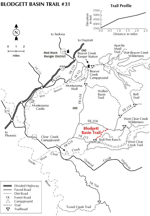
You'll drop 1,700 feet in about 2.5 miles on this trail, enjoying good views of scenic West Clear Creek Canyon along the way. The trail begins on a pinyon juniper flat and switchbacks down a moderately steep slope into the canyon. The trail was constructed as a route to move cattle between seasonal pastures. It still serves that purpose, at the same time being a recreational resource for forest visitors.
As you follow its winding route, you'll want to take time out from watching where you step to take advantage of the excellent view of one of the rarest habitats in the world. West Clear Creek is home to a healthy example of a desert riparian zone. Some would call it an oasis. It supports an exceptionally diverse plant and animal community. Biologists say that up to 80% of Arizona's wildlife species are dependent on this productive habitat.
The trail arrives at West Clear Creek at an area that is popular for fishing, camping, and just plain splashing around. Another way to approach this hike is to start at the Bull Pen Ranch Trailhead and hike up the Blodgett Basin Trail for the view.
Rating: Moderate
Hiking time: 2 hours, round trip
Notes: No motorized vehicles
USGS Map(s): Walker Mtn.
At a Glance
Open Season:
Year 'round
Usage:
Light
Best Season:
March through December
Operated By:
Red Rock Ranger District - 928-203-2900
General Information
Latitude: 34.540230
Longitude: -111.707799
Length: 2.5 miles
Elevation: 3587 at trailhead
General Notes:
Accessibility: Directions:
Location: 53 miles south of Flagstaff on paved and graveled forest roads in picturesque Desert Canyon Country.
Access: Drive 40 miles south of Flagstaff on Interstate 17 to the AZ 179 exit and turn east under the freeway. Drive about 9 miles on FR 618 to FR 214. Turn east and drive 4 miles to the trailhead on the right side of the road just beyond a cattle guard.
Or: Drive about 9 miles from I-17 on FR 618 to FR 215 and turn east about 3 miles to the Bullpen Ranch trailhead. The Blodgett Basin Trail branches off the West Clear Creek Trail about a half mile from the trailhead.