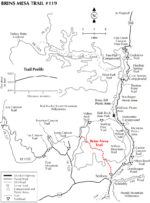
This trail begins right at the edge of the town of Sedona and is as picturesque as it is convenient. Instead of keeping you tucked away in a deep canyon or clinging to the side of a steep slope as do a lot of other trails in this area, it leads you right out into the open where you can enjoy unobstructed views of the spectacular red rock formations for which the Sedona area and Oak Creek Canyon are famous. Bring along a map to help you identify Coffee Pot Rock, Wilson Mountain, Chimney Rock and more.
The hike is not too steep and not too long, but it can be a bit hot during summer. No matter, you'll be glad you braved the heat (and the shooting range at the Sedona trailhead) when you see the views. An alternate approach to the Brins Mesa Trail is to drive out Vultee Arch Road and hike it from that end-same trail, same great views.
Rating: Easy
Hiking time: 1 hour
Notes: No mechanized vehicles (including mountain bikes) in Wilderness.
This trail can be hot and dry in summer. Please do not disturb ruins or remove artifacts.
USGS Maps: Munds Park, Wilson Mountain
At a Glance
Open Season:
Year 'round
Usage:
Light-Medium
Operated By:
Red Rock Ranger District - 928-203-2900
General Information
Latitude: 34.917018
Longitude: -111.808763
Length: 3.2 miles
Elevation: 4632 at trailhead
Directions:
Location: 28 miles south of Flagstaff (1 miles north of Sedona) on paved and dirt Forest roads in scenic red rock country. Elevation at the trailhead is 4200 feet.
Access: From Flagstaff, drive 27 miles south on US 89A to Sedona and turn west (right) on Jordan road. Follow it about a mile to the trailhead. Or continue through Sedona to Dry Creek Road, turn north about a mile to Vultee Arch Road (FR 152) and north about 2.5 miles to the Soldier Pass trailhead. It's a mile and half hike to the Brins Mesa Trail intersection. The last 1/4 mile of Jordan Road and all 3 miles of FR 152 can be a bit rough.