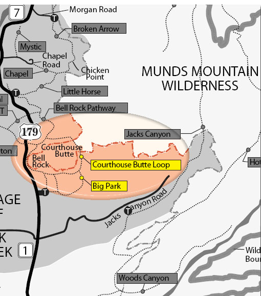
There are two access points to this wonderful trail:
From the south (Bell Rock Pathway and Vista) take the wide Bell Rock Pathway from the kiosk toward Bell Rock. It climbs gently and at ½ mile there is a signed intersection with the Courthouse Butte Loop Trail. Continue ahead on the wide trail (this description is for taking the loop clockwise). The trail continues a gentle climb circling to the west of Bell Rock. It levels out and curves to the north below the slopes of Bell Rock.
From the north: (Courthouse Vista) walk southeast on the trail directly towards Bell Rock at ¼ mile the Trail intersects Bell Rock Pathway to you may then choose to circle Bell Rock and Courthouse Butte clockwise (turn east) or counterclockwise (turn west).
If circling clockwise, after turning east, follow the large cairns to the point where the wide Pathway turns north (left) and a sign shows the Courthouse Butte Loop Trail branching to the east. Go east. This narrower trail passes to the north of Courthouse Butte heading toward Lee Mountain. The next intersection is the Llama trail, popular with mountain bikers, from the north. Continuing east, the trail passes to the right of a prominent dome-shaped outcrop, and then gradually descends, entering Wilderness. It enters a dry wash, circles to the south over bare rock and climbs out onto level ground as it leaves the Wilderness area and continues to circle Courthouse Butte. Approaching Bell Rock, the trail meets the pathway once again. To return to the Bell Rock Vista and Pathway trailhead, go south, retracing the entry route for ½ mile to return to the kiosk. If returning to the Courthouse Vista Trailhead, continue clockwise around Bell Rock to the intersection of the parking area trail intersecting from the northwest. The loop is mostly un-shaded and can be hot in summer.
Red Rock Pass required (or its equivalent) - Minimum $5.00
Open Season:
Year 'round
Usage:
Heavy
Busiest Season:
Summer
Closest Towns:
Village of Oak Creek, Sedona, AZ
Restroom:
Vault-type toilet at trailheads
Operated By:
Red Rock District - 928-203-2900
General Information
Latitude: 34.791030
Longitude: -111.76279
Length: 4.2 miles
Elevation: 4188 at south trailhead
General Notes:
Directions:
Location: 38 miles south of Flagstaff in scenic Red Rock Country.
Access:
South Trailhead: Bell Rock Vista and Pathway trailhead (South of Bell Rock): from the junction of Routes 89A and 179 in Sedona, take 179 south 6.5 miles to a left turn lane marked for Bell Rock Vista, milepost 307.1 for the south trailhead.
North Trailhead: Courthouse Vista Trailhead (north of Bell Rock): From the junction of Routes 89A and 179 in Sedona, take 179 south 5.2 miles to a left turn lane marked for Courthouse Vista, milepost 308.2. Turn left, then across the northbound lane to the trailhead on the east side of the road.