This trail features easy riding on fast open trails next to wilderness canyons and is a "connector trail" between the Long Canyon Trail and the Boynton Canyon Trail. This trail has a little bit of everything in the way of riding terrain - dirt road at the start, wide dirt trail along Long Canyon Trail and finally single track riding (some over rocks) on the Deadmans Pass trail.
Rating: Easy
Trailhead Elevation: 5120 (300 ft. gain)
Uses: Hiking, equestrian, and mountain biking
Hiking time: approximately 30 min. one-way
Notes:
Should you venture northward on either Long Canyon Trail or Boynton Canyon Trail you would be in the Red Rocks/Secret Mountain Wilderness. No mountain bikes, wheeled devices, or mechanized transportation allowed in Wilderness
At a Glance
Open Season:
Year 'round
Usage:
Medium
Closest Towns:
Sedona, AZ
Operated By:
Red Rock District - 928-203-2900
General Information
Latitude: 34.907701
Longitude: -111.84900
Length: 1.4 miles
Elevation: 4521 at trailhead
Accessibility: Directions:
USGS Map(s): Wilson Mountain
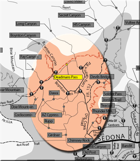
Location: Just north and slightly west of Sedona
Access: Drive 27 miles south from Flagstaff on US 89A through Sedona to Dry Creek Road. Turn north (right) about a mile and a half to Long Canyon Road (FR 152D) and north (right) again about 0.5 miles to the Long Canyon trailhead on left. Take the Long Canyon Trail about 3/4 mile to junction of Deadmans Pass Trail.
Alternately, you may turn southwest (left) at Long Canyon Road/Boynton Pass Road (FR 152C) junction to the Boynton Canyon trailhead. Park here and hike a .25 miles to the junction of the Boynton and Deadmans Pass trails.