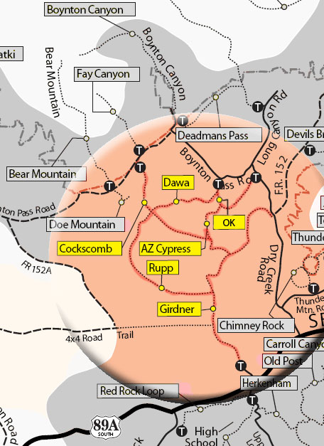
The trail may be hiked one-way with arranged transportation and would be rated moderate. The route north from the Cultural Park Trailhead to the Dry Creek Road Trailhead is described here. The trail begins near the ramada and interpretive signs and descends gradually to the north, then northwest, with good views. At 1 mile, it begins a moderate descent to the west, bends north and enters the Dry Creek drainage. After two crossings of the drainage, the trail meets the gas pipeline access road (closed to motor vehicles) at 1.5 miles. It follows the road for about 1/8 mile, then branches north and rejoins Dry Creek which it follows for the next 1.2 miles. This portion of the trail involves crossing the normally dry creek many times in a rather narrow, shallow canyon and should not be hiked following heavy rain.
The trail intersects the Rupp Trail (see "Cockscomb Area Trails") branching uphill to the left following an old roadbed at 2.8 miles. Cross the creek and follow the same road (closed) as it climbs out of the drainage to the northeast and circles to the southeast for 1/4 mile. Here at the road blockage, the trail forks left and climbs moderately to the crest of a ridge with nice views of the mountains to the north. It now descends to the east toward Capitol Butte. At 3.5 miles, the Arizona Cypress trail branches left. Continue east for 1/8 mile and after crossing a wash the second time, bear left at the intersection with the Two Fence Trail (not shown on map) which goes right. The trail climbs moderately, tops out, then descends to the east and levels out. As it approaches Dry Creek Road, the trail bears right and parallels the road a short way and ends at the signed trailhead about 50 feet north of the intersection with unpaved FS 152.
Elevation: at the Cultural Park Trailhead, elevation of 4,500 feet drops 260 feet to 4,240 feet. Then it gains 360 feet to 4600 feet and then drops back down to just over 4,500 feet at the end of 4.5 miles.
Rating: Strenuous (roundtrip)
Hiking Time: allow 4 hours roundtrip
Uses: Hiking, bicycling, horses
USGS Map: Wilson Mountain
At a Glance
Open Season:
Year 'round
Operated By:
Red Rock Ranger District - 928-203-2900
General Information
Latitude: 34.852527
Longitude: -111.831457
Length: 4.5 miles
Elevation: 4485 at Cultural Park Trailhead
Directions:
Location: 38 miles south of Flagstaff in scenic Red Rock Country.
Access: Cultural Park Trailhead: From the intersection of Routes 89A and 179, take 89A west 4.2 miles to Cultural Park Place on the right at the traffic signal. Go north 2.2 miles to the picnic ramada and interpretive displays on the right.
Dry Creek Road Trailhead: From the intersection of Routes 89A and 179, take 89A west 3.2 miles to Dry Creek Road on the right. Go 1.9 miles to unpaved FS 152 on the right and park near this intersection. The signed trailhead is about 50 feet north on the west side of the paved road.