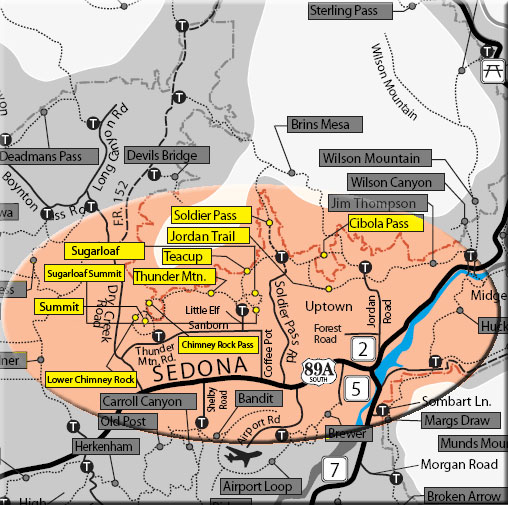
The North Urban Trail System is an interconnected series of trails north of Sedona along the red rock front country. These trails extend from the Jim Thompson Trailhead on the east end to the Thunder Mountain Trailhead to the west. The eastern portion, described here, includes the above listed trails. These trails may be reached using the three trailheads shown below under "access".
Beginning on the east side, the Jordan Trail and Cibola Pass Trail can be accessed from the Jim Thompson Trailhead at the north end of Jordan Road. These trails can be hiked as an easy scenic loop of 2 miles in partial shade with an elevation gain of about 200 feet. Either can be used to reach the Soldier Pass area and the Devil's Kitchen sinkhole to the west, a distance of 1.3 miles with an elevation gain of about 200 feet (one-way). The Jordan Trail is open to mountain bicyclists, the Cibola Pass and Brins Mesa Trails are closed to mountain bicycles given these trails are located within the wilderness.
Continuing to the west, the Soldier Pass Trail crosses the Jordan Trail near the Devil's Kitchen sinkhole. The Soldier Pass trailhead is located approximately .2 miles to the south. The Teacup Trail, mostly un-shaded, meanders west past the base of Coffee Pot Rock and climbs moderately to the base of Sugarloaf Hill to the south. On the south side of the Sugarloaf Loop Trail, the Summit Trail can be taken to climb 250 feet to the top of this hill for marvelous panoramic views. The Teacup Trail continues southwest a bit further to the Sugarloaf Trailhead parking area, 1.8 miles from the Soldier Pass area. The Teacup Trail intersects the Thunder Mountain Trail, the link to the western portion of the North Urban Trail System - West (described separately), .3 miles north of the Sugarloaf Trailhead. See the map below.
At a Glance
Open Season:
Year 'round
Usage:
Medium
Operated By:
Red Rock District - 928-203-2900
General Information
Length: 2 to 6.5 miles, depending on route used
Mountain Biking
Bicycles prohibited on Cibola Pass Trail in Wilderness
Directions:
Rating: Easy / Moderate
Hiking Time: 1 to 4 hours, depending on route used
Uses: Hiking, bicycling, horses (Bicycles prohibited on Cibola Pass Trail in Wilderness)
USGS Map: Wilson Mountain/Sedona
Location: 38 miles south of Flagstaff in scenic Red Rock Country.
Access:
Jordan Road Trailhead - From the junction of Routes 89A and 179, take 89A north .3 miles to Jordan Road on the left. Follow Jordan Road into the Jordan Park Subdivision and turn left onto park Ridge Drive at the "T". Continue .4 miles and park near the end of the short stretch of unpaved road in front of the gate.
Soldier Pass Trailhead - From the junction of Routes 89A and 179, take 89A west 1.2 miles to Soldier Pass Road on the right. Go 1.5 miles to Rim Shadows Drive, then right .2 miles, keeping straight ahead, to a gated entry road to trailhead parking on the left.
Sugarloaf Trailhead - From the junction of Routes 89A and 179, take 89A west 2 miles to Coffee Pot Drive on the right. Go .5 miles to Sanborn Drive on the left, then .2 miles to Little Elf Drive on the right. Go .2 miles to the end of Little Elf and turn right on Buena Vista Drive for 50 yards to the trailhead parking area on the left.