Just getting to this trail is an adventure. The last mile of primitive road that leads to the trailhead is a place of tire bruising rocks and bottom scraping ruts. Actually, it might be a good idea to hike or mountain bike it, so you don't abuse your car driving it. Don't try it at all without a sturdy, high clearance vehicle. There is a FS/APS gate about 300 yards from the trailhead sign.
Once you get to the trailhead you'll forget all about that rocky ride. The view is magnificent-Grand Canyon quality. You can see into Mooney Canyon, part of the lower Oak Creek basin, and Sycamore Canyon at the same time. In Sycamore, sheer walls, towering buttes, teetering pinnacles and huge lava flows stretch to the horizon.
Taylor Cabin Trail provides good views of all this then drops into a sheltered drainage which it follows to the canyon floor. The steepest part of the climb is mercifully shaded by Douglas firs and ponderosa pines. At trail's end, on the floor of Sycamore Canyon, you'll find everything associated with a desert river except the river itself. Rounded boulders and gnarled sycamore trees attest to the fact that water flows here regularly, but unless you come during the snowmelt or after a thunderstorm, you won't see it. Some of the larger pools hold water into late spring, but eventually they all dry up.
Taylor Cabin, a historic old rancher's shack listed in the National Register of Historic Places, is about a mile and half downstream. You can either boulder hop down the stream bed to it or follow the Sycamore Basin Trail. That trail is directly across the main stream bed from the end of the path you have just walked down. Following the trail is the best way of finding the cabin, otherwise you could boulder hop right past it.
Rating: Very strenuous
Hiking Time: 2.5 hours round trip
Notes:
Bring lots of water-it's hot and steep.
No motorized or mechanized vehicles (including mountain bicycles) in the Wilderness.
High clearance vehicles only to trailhead.
Use experienced trailhorses.
The Sycamore Canyon Wilderness Map is available by phone using Visa or MasterCard by calling 928-203-2900.
At a Glance
Open Season:
Year 'round
Usage:
Medium
Best Season:
April - November
Closest Towns:
Sedona, AZ
Operated By:
Red Rock District - 928-203-2900
General Information
Latitude: 34.98606
Longitude: -111.94613
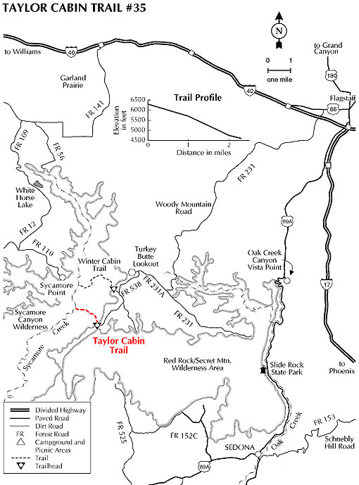
Length: 2.9 miles
Elevation: 6307 at trailhead
Directions:
USGS Map(s): Loy Butte, Sycamore Point
Location: 30 miles south of Flagstaff on graveled and dirt forest roads.
Access: Drive south from Flagstaff 20.8 miles on FR 231 (Woody Mountain Road). Turn right on FR231A past the Turkey Butte Lookout Tower and drive 3.3 miles to FR 538. Follow this road 3 miles south past FR 538H (to Winter Cabin Trailhead) and a number of unmarked Forest Roads (when in doubt stay with the power line). Do not try to drive beyond the parking area under the power line at mile 2.9 - it's only a few hundred yards to the trailhead. At the trailhead, take the path that leads to the right behind the sign. The one to the left is a dead end.