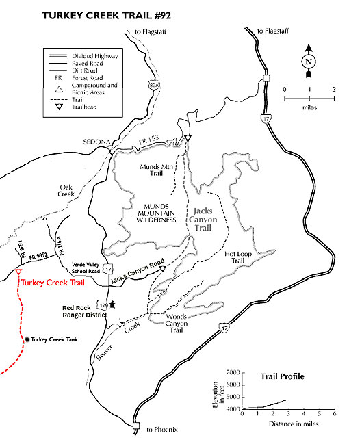
This seldom used trail offers vistas and interesting geology. Follow the blocked road, taking the right fork at 0.3 miles. The unshaded road winds in a southwesterly direction with some gentle ups and downs for 1.5 miles to Turkey Creek Tank on the left. Here, the road bends to the left and dies out. The trail continues, crossing normally dry Turkey Creek and beginning a gradual climb in the sparse shade of pinyon pine and juniper.
At 2.25 miles, it begins a moderately steep switchback ascent of the north face of House Mountain, a long extinct shield volcano. There are fine views of nearby red rock formations as well as more distant vistas north toward Wilson and Secret Mountains. The trail reaches the crest at nearly 3 miles and begins a gradual descent over basaltic lava. Soon the view over the ancient, heavily eroded caldera opens up and the opposite rim, dominated by the lava outcrop which gave the mountain its name, is visible. The trail continues, but this is a good stopping point. Return by the same route for a 6 mile roundtrip hike. This hike can be very hot in summer.
Rating: Moderate for hiking; Strenuous for biking
Hiking Time: Allow 4 hours roundtrip
Notes:
Trail climbs 600 feet along dry Turkey Creek, past Turkey Creek Tank, and ultimately onto House Mountain with spectacular views.
Very secluded and diverse area.
Open to horse, bike, and foot use.
At a Glance
Open Season:
Year 'round
Usage:
Medium
Closest Towns:
Sedona, AZ
Operated By:
Red Rock District - 928-203-2900
General Information
Latitude: 34.809596
Longitude: -111.817799
Length: 3.4 miles
Elevation: 4000 trailhead
Directions:
USGS Map: Sedona
Location: 4.5 miles west of the Village of Oak Creek in scenic Red Rock Country.
Access: From the junction of Routes 89A and 179, take 179 south 7.2 miles. Turn right at the traffic signal on Verde Valley School Road. Go 4.1 miles to road on left signed for Turkey Creek Trail. Take this unpaved road (rough but passable by any vehicle) 0.5 miles and take left fork 100 feet to road's end.