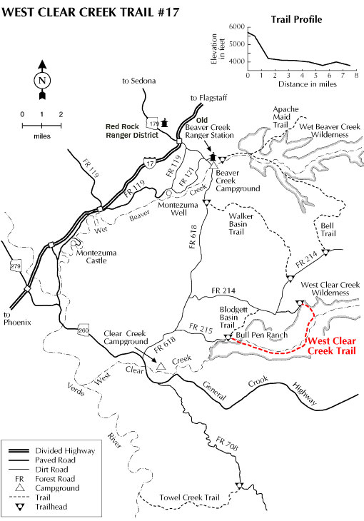
This trail provides the only marked and maintained access to the lower reaches of West Clear Creek Canyon Wilderness. From its western terminus at Bull Pen Ranch at the canyon mouth, the trail leads upstream into the deep, narrow gorge which medium-sized West Clear Creek has cut into the southern edge of the Colorado Plateau.
The downstream end of the trail attracts large numbers of anglers, picnickers, and other streamside recreators attracted by the clear pools, slickrock water slides, and tree-shaded riparian areas tucked away between red rock canyon walls. The photo above is of the Hanging Gardens with an otter highlighted in the center. Click on "Photos & Multimedia" in the right column for enlarged view.
From the trail's upper terminus, at Bald Hill, the route drops 1,800 feet down a steep, talus - strewn slope from a high plateau of pinyon-juniper forests to the canyon floor. It then winds its way downstream along a stretch of secluded pools and rocky riffles. Bring your wading shoes on this one, you'll have to cross the stream at least four times. In times of high runoff, this trail can be impassable. In the middle of a hot desert summer you'll appreciate the opportunity to cool off.
Rating: Easy/Strenuous
Hiking time: 4.5 hrs
Notes:
No mechanical vehicles in Wilderness, respect private property boundaries.
Steep sections of this trail can be a problem to a hiker loaded with a heavy backpack.
At a Glance
Open Season:
Year 'round
Usage:
Medium
Closest Towns:
Camp Verde, AZ
Operated By:
Red Rock District - 928-203-2900
General Information
Latitude: 34.540231
Longitude: -111.707800
Length: 7.5 miles
Elevation: 3587 at trailhead
Directions:
USGS Map(s): Walker Mtn., Buckhorn Mtn.
Location: 52 miles southeast of Flagstaff on paved and graveled roads in scenic red rock country.
Access: Drive 40 miles south of Flagstaff on Interstate 17. Leave the highway at the AZ 179 exit and turn east under the freeway. Drive about 9 miles on FR 618 to FR 215 and turn east about 3 miles to the Bullpen Ranch trailhead.
Or, turn east off FR 618 on FR 214 about 8 miles from the highway and turn east 4.7 miles to the Bald Hill Road. Follow this primitive road about 1 mile to a rock-pile cairn that marks the trailhead.