There are a number of reasons why West Fork is the most popular trail on the Coconino National Forest. You'll know some of them once you've strolled beside the pleasant little stream that ripples along the canyon floor and looked up, way up, at the dizzying cliffs that tower above it. You'll know even more if you come in the spring,when migrating songbirds decorate the trees with flashes of brilliance, or in the fall when pastel leaves float in clear reflecting pools under a canopy of solid color. You can even add to that list if you come in the winter, when icicles hang from red rock overhangs and snatches of snow persist in cool shadows. As a matter of fact, you'll probably find a new reason to be here every time you visit.
As for the trail itself, it's an easy stroll, but you do have to cross the stream in a number of places. Usually, that involves negotiating a few strategically placed stepping stones or taking a couple of steps in shallow water. The trail is marked for the first three miles; however, many hikers continue beyond that. Eventually the pathway ends and you will be forced to hike in the stream bed as you continue into the Secret Mountain/Red Rocks Wilderness. If you choose to travel all 14 miles from one end of the canyon to the other, plan to do a lot of wading and boulder hopping, and even some swimming.
No matter how long a hike you take here, you'll enjoy it best if you come at a time when the trail is least crowded. Mornings and weekdays are best, better yet if they're in the off-season.
When you do come, remember to take special care and leave this beautiful place better than you found it. Of course you know not to litter, but picking flowers and autumn leaves can cause just as unsightly a scar. So can short-cutting or rock throwing. Treat this natural treasure with the care it deserves and you'll have plenty of reason to come back and see it again and again.
Rating: Easy
Hiking time: 2-3 hours round trip
Notes:
No mechanized vehicles in Wilderness.
This trail can become extremely crowded, especially on summer weekends.
It will be closed during times of high fire danger, usually in late June.
USGS Maps: Dutton Hill, Mountainaire, Wilson Mtn., Munds Park
At a Glance
Operational Hours:
Season: All year, Summer 9 a.m. to 8 p.m., Winter 9 a.m. to dusk. (Generally, the gate is open by 8 a.m. and if the host is not available, there is a self-pay system.)
Fees
Day-use is $9 per vehicle (up to 5 people), walk-in, bicycle, bus: $2.00 per person. In lieu of this fee, the Big Three Pass or the Grand Annual Red Rock Pass will be accepted here.
Open Season:
Year 'round
Usage:
Heavy
Busiest Season:
Summer
Closest Towns:
Sedona, AZ
Water:
No Drinking Water
Operated By:
Concessionaire - call Red Rock District - 928-203-2900
Information Center:
The West Fork of Oak Creek Trailhead (Call of the Canyon Picnic Area) is operated by a concessionaire. Only the Grand Annual Red Rock Pass and the "Big Three" annual pass, (each $40.00) are accepted here, or you may pay the daily rate at the gate.
General Information
Latitude: 34.990560
Longitude: -111.743195
Length: 3.2 miles
Elevation: 5325 at trailhead
Directions:
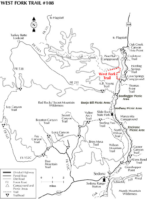
Location: 17.5 miles south of Flagstaff (9.5 miles north of Sedona) on paved roads in scenic Oak Creek Canyon.
GPS: N34° 59' 25.3314", W-111° 44' 14.244"
Access: Drive south 17.5 miles south from Flagstaff or north 9.5 miles from Sedona to about halfway between milepost 385 and 384. The trailhead is on the west side of the highway down a paved lane that leads behind a few creekside houses. Park at the Call O' The Canyon day-use area.
General Notes:
The Call of the Canyon Day-Use Area is at the Trailhead of the West Fork Trail.
There are 6 picnic table sites; toilets; parking area for the West Fork Trail. Call of the Canyon is operated by Recreation Resource Management and is a fee area.