This hike heads straight for some of the most panoramic views in the Oak Creek Canyon/Sedona area. Plan a full day for it and start early - the climb up Wilson Mountain is a strenuous one. The majority of the 2300 foot climb is packed into the first mile or so of the hike. You'll have more reasons than just exertion to stop and take a breather along this route, however. The views start as soon as you leave the car and they just keep getting better.
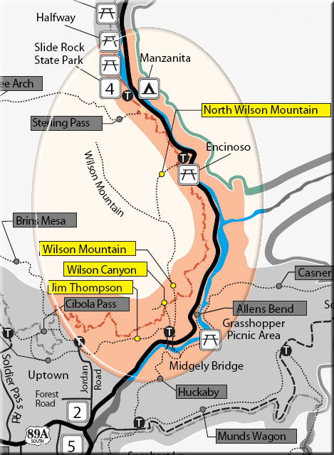
There is shade along parts of this trail but enough of it is out in the open to make it hot work under a summer sun. An alternate, cooler route is provided by North Wilson Trail which starts just north of Encinoso Picnic Area, 3 miles up canyon from Midgley Bridge. The two trails join at a point midway up the mountain.
At the top you'll be rewarded with views that stretch over hundreds of square miles of scenic canyon country and include Oak Creek Canyon, Sedona, Coffee Pot Rock, Capitol Butte, Sterling Canyon and the Verde Valley.
Rating: Strenuous
Use: Moderate
Hiking time: 5 hours round trip
Notes:
No mechanized vehicles in Wilderness.
This trail can be hot in summer.
At a Glance
Open Season:
Year 'round
Usage:
Light-Medium
Best Season:
April to November
Closest Towns:
Sedona, AZ
Operated By:
Red Rock District - 928-203-2900
General Information
Latitude: 34.886629
Longitude: -111.741935
Length: 5.6 miles
Elevation: 4526
Directions:
USGS Maps: Wilson Mtn., Munds Park
Location: 22 miles south of Flagstaff (2 miles north of Sedona) on paved roads in scenic Oak Creek Canyon. Elevation ranges from 4600' to 6900'.
Access: Drive 22 miles south of Flagstaff or 2 miles north of Sedona on U. S. 89A. The trailhead is just north of Midgley Bridge where you'll find a small parking lot and a monument to Richard Wilson who was killed by a grizzly in this area in 1885.