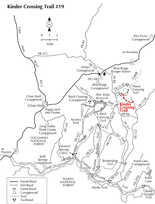
This trail offers a picturesque access to East Clear Creek, crossing the creek near a moderately deep section. There are excellent opportunities for fishing and sightseeing. Expect the trail to be steep and rocky in places. Some hikers limit their trek to the three-quarter mile hike to the creek. Others, however, venture across the creek for the additional three-quarter mile section. No cairns or blazes mark the extended trail which heads downstream then turns east up ridge and connects with FR 137. Kinder Crossing Trail was featured as "Hike of the Month" in the April 2000 issue of Arizona Highways magazine. Motorized vehicles are not allowed on this trail. FR 95T is usually closed each winter during heavy snow season.
HIGH CLEARANCE VEHICLES are recommended due to rutted and rocky condition of FR 95T.
Road can be very slick when wet and closed to vehicles in winter.
At a Glance
Open Season:
Spring
Usage:
Medium
Closest Towns:
Happy Jack, AZ
Operated By:
Mogollon Rim District - 928-477-2255
General Information
Latitude: 34.570005
Longitude: -111.149101
Area/Length: 1.25 miles
Elevation: 6431'
Directions:
Location: Southeast of Flagstaff
Access: From Clints Well go north on Highway 87 approximately 10 miles, milepost 300, just beyond the Mogollon Rim Ranger District. Turn right (south) on FR 95. Drive about 4.5 miles to FR 95T and turn left (east). Go 0.6 miles to the trail sign at fork in the road. The actual trailhead is 0.1 mile to the right.