Arizona's Best Swimming Holes  


HS Canyon Trail #50

Upload GPS Tracks
Upload Trail Photos

Download this GPS TrackRight Click and "Save Link As.."

Trail Ratings
Overall Trail Rating
1 = Poor 5 = Outstanding

Scenic Views
 
Route Finding
1 = Poor 5 = Excellent
 
Technical Difficulty
1 = Easy 5 = Very Difficult
 
Trail Access
1 = Easy 5 = Hard to get to
 

This is an infrequently used trail. It is sufficiently shaded to allow hiking in summer.

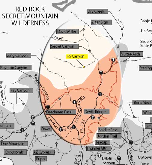
Start on Secret Canyon Trail. Its signed trailhead is across the usually dry streambed of Dry Creek west of the parking area. It immediately enters Wilderness. Follow this wide, nearly flat trail for 2/3 mile and look for the sign for HS Canyon Trail on the left. The trail climbs gradually in the shade of oak and alligator juniper.

At about 1.5 miles from the parking area, views of red rock formations open up. The trail narrows further as it climbs moderately beside the small canyon drainage. At 2.25 miles, the trail approaches the sheer face of Maroon Mountain and switchbacks up to a small clearing for nice views of the mountain and the end of the box canyon. Return by the same route for a 5 mile rountrip hike.

Rating: Strenuous

Uses: Hiking. Too narrow for horses; bicycles prohibited in Wilderness.

Hiking time: Allow 3 hours roundtrip

Note: Bicycles prohibited in the wilderness


See also, Secret Canyon Loop Trails

At a Glance

Open Season: Year 'round
Usage: Light
Closest Towns: Sedona, AZ
Operated By: Red Rock District - 928-203-2900

General Information

Latitude: 34.938567

Longitude: -111.810240

Length: 2.5 miles

Elevation: 4717

Directions:

USGS Maps: Wilson Mountain

Location: 35 miles south of Flagstaff in beautiful Red Rock Country.

Access: From the junction of Routes 89A and 179, take 89A west 3.2 miles to Dry Creek Road on the right. Go 1.9 miles to FS 152 on the right. Take this unpaved road 3.4 miles to trailhead parking on the left. High clearance vehicles recommended for Forest Road 152 but this road should be avoided in wet weather.


General Notes:


HS Canyon Trail #50


Comments

comments powered by Disqus


Camping Regions
Camping Regions

Central Arizona
Flagstaff / Sedona / Prescott
Northeast / Grand Canyon
Payson / Mogollon Rim
Southeast / Tucson
White Mountains
Western Arizona


Camping
Resources

Camping Checklist
Camping Gear
Our You Tube Videos
Camping Recipies

Arizona Game and Fish Department

Fishing Reports
Lake Levels
Stocking Schedule
AZ Fishing Rules & Regulations
Where to Fish
Sport Fish Species
Urban Fishing

U.S. Forest Service
National Forests in Arizona

Apache Sitgreaves N.F.
Coconino N.F.
Coronado N.F.
Kaibab N.F.
Prescott N.F.
Tonto N.F.


Site Map
Advertising Information
Contact Us
Links


All campground rates and information are subject to change without notice.


Home | Campgrounds | Hiking Info |Camping Checklist | Fire Information
Western Arizona RV Parks | Fishing Reports | Contact Us | Links
Site Map

All original material and HTML coding © 2004-2021 camparizona.com

Terms of Service | Privacy Policy


Arizona Game and Fish Department U.S. Forest Service