Secret Canyon/David Miller/Bear Sign/Dry Creek Trails Loop
A scenic red rock country loop which involves the use of four trails. It can be hiked in either direction. The clockwise direction loop starting from the Secret Canyon Trailhead is described here.
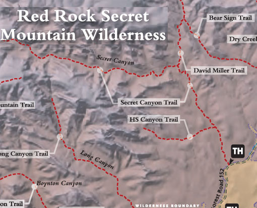
Start at the signed trailhead for the Secret Canyon Trail across the usually dry streambed of Dry Creek west of the parking area. The trail immediately enters Wilderness. The wide, nearly flat trail leads into the wide canyon mouth with nice views, but no shade. At 2/3 mile, the HS Canyon Trail branches off to the left. Continue ahead. At 1.75 miles, turn right onto the David Miller Trail at the signed fork. It climbs gently for about .5 mile then more steeply for another .25 mile to a saddle which overlooks Bear Sign Canyon and the Dry Creek drainage area.
The trail now descends steeply 200 feet into Bear Sign Canyon and ends at its intersection with the Bear Sign Trail. Turn right and follow this shady trail to the southeast as it gradually descends beside the canyon drainage for 2.25 miles to the confluence of the Bear Sign and Dry Creek washes. This is also the trailhead for the Bear Sign Trail. Turn right and follow the Dry Creek Trail southward. It follows the usually dry streambed on a gradual descent except for one short climb out of the drainage which allows views over the canyon. After nearly .75 miles on this trail, it crosses the creek, turns left and ends at the trailhead parking area shared with the Vultee Arch Trail.
To complete the loop, follow the road southwest for about 1 mile to return to the Secret Canyon Trail parking area.
Rating: Strenuous
Uses: Hiking, horses. (Bicycles prohibited in Wilderness)
Hiking time: Allow 3 hours roundtrip
At a Glance
Open Season:
Year 'round
Usage:
Medium
Closest Towns:
Sedona, AZ
Operated By:
Red Rock District - 928-203-2900
General Information
Length: 6.2 mile loop
General Notes:
Directions:
Location: About 42 miles south of Flagstaff (12 miles west of Sedona) on paved and graveled roads.
USGS Map: Wilson Mountain
Access: Drive 27 miles south from Flagstaff to Sedona on US 89A. Continue through Sedona to Dry Creek Road (152C) at the west end of town. Turn right on Dry Creek Road and drive for two miles to Forest Road 152. This road is rough; high clearance vehicles recommended. It is not recommended during wet weather. About 4.3 miles up this road you will reach a small sandy opening or turn-a-round. Park here and proceed hiking out the east end of the opening along a short jeep trail which dead ends at a drainage. Continue on the foot path up the canyon.