Little Horse Trail begins as part of the Bell Rock Pathway. Follow this wide trail southward for ¼ mile. Here, at a signed fork, take the old jeep road branching to the left and marked with basket cairns. The road drops to cross a dry streambed, climbs a bit and ends at the ¾ mile point. The trail continues to the left and climbs moderately, topping out on a large, flat expanse. Turn to the right here. The level trail leads into a stand of Arizona cypress and intersects a trail on the left coming from the chapel as it nears the "Madonna and the Nuns" spires. Nice views. At 1.4 miles, it passes through a gate.
Continue for 150 yards passing the base of the knobs of Chicken Point on the left. Take the path left for a short climb onto the bare rock for wonderful views. This point is used by jeep tours via Broken Arrow Road. Return by the same route for a 3 mile roundtrip hike or exit the area by going north on the Broken Arrow Trail with arranged transportation at its trailhead. The hike can also be extended eastward from the base of Chicken Point into the Wilderness area (no bicycles allowed) on the Jim Bryant Trail. Little Horse Trail is mostly unshaded and hot in summer.
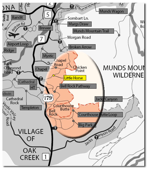
At the little horse trailhead, there is a sign with a map of the trail.
Rating: Easy
Hiking Time: 2 hours roundtrip
At a Glance
Open Season:
Year 'round
Usage:
Medium
Closest Towns:
Sedona, AZ
Operated By:
Red Rock Ranger District - 928-203-2900
General Information
Latitude: 34.818599
Longitude: -111.771367
Length: 1.5 miles
Elevation: 4191
Directions:
USGS Map: Sedona
Location: 35 miles south of Flagstaff in scenic Red Rock Country.
GPS: N34° 49' 6.3474", W-111° 46' 17.076"
Access: From the junction of Routes 89A and 179 in Sedona, take 179 south 3.6 miles to a paved turnout and trailhead parking on the left (east) at milepost 309.8, .2 miles south of the entrance to the United Methodist Church.