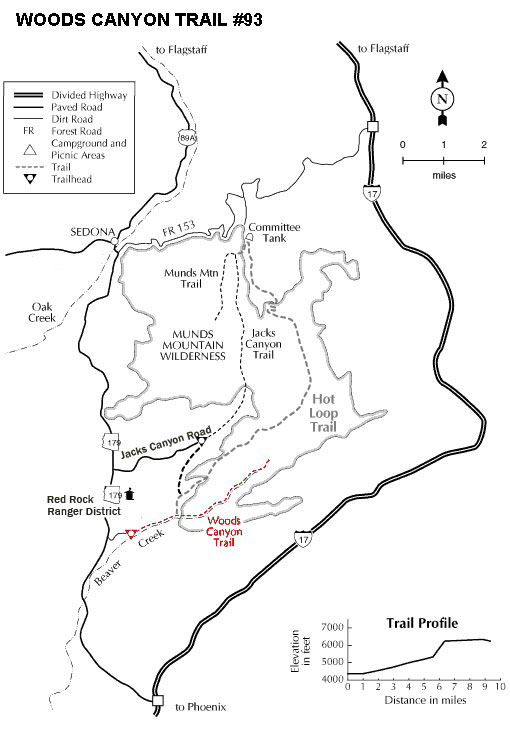
The trail begins at the signed trailhead beyond the gate. It is level and unshaded as it follows a jeep road into the wide canyon mouth for 1-1/4 miles. The road ends and the trail continues, climbing gradually. There are views of the vegetation-covered slopes of mesas on either side. At 2 miles, the trail crosses a small, dry streambed with red rock pools, climbs out, passes through a cattle gate, and comes to a signed fork.
The Hot Loop trail enters Wilderness area and continues its easy climb, passing some redrock formations on the left. It enters the occasional shade of pine and sycamore as it approaches and then follows Dry Beaver Creek. At 3-1/2 miles, the trail emerges on a picturesque expanse of redrock at the edge of the usually dry creekbed which is studded with huge, gray boulders. Continue on for another 3/4 mile for some nice redrock views as the trail climbs on a moderate grade out of the creekbed. This is a good place to turn around although a path continues further into the canyon. Return by the same route. This hike can be hot in summer.
Rating: Easy
Hiking time: allow 4 hours round-trip
Notes:
No motor vehicles, No mechanized vehicles in Munds Mtn. Wilderness.
At a Glance
Open Season:
Year 'round
Usage:
Medium
Closest Towns:
Sedona, AZ
Operated By:
Red Rock District - 928-203-2900
General Information
Latitude: 34.756946
Longitude: -111.763455
Length: 4.25 miles
Elevation: 3883 at trailhead
Directions:
USGS Map: Munds Mountain, Sedona
Location: 42 miles south of Flagstaff (11.5 miles east of Sedona) in scenic Red Rock Country.
GPS: N34° 45' 25.0554", W-111° 45' 48.096"
Access: From the Junction of US 89A and 179 in Sedona, head south on 179 and drive about 8.4 miles to a gated, unpaved road on the left (east) at milepost 304.7. Park outside the gate.