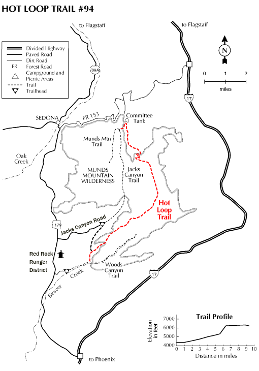
Two things are hot about this trail. That's the way you'll feel when you complete the climb to the top of Horse Mesa and that's the way you'll describe the views when you get there. There's actually two ways to approach the Hot Loop, one is from a trailhead in Jacks Canyon near the Pine Flat Subdivision. The other is a trailhead in Woods Canyon off AZ 179.
From the Jacks Canyon Trailhead (which has the best parking lot) a connector trail leads up and over a low saddle to join the Hot Loop just as it begins the steepest part of its 1,000 foot climb to the top of Horse Mesa.
From the Woods Canyon Trailhead, you can access this trail by following an old jeep road from AZ 179 to the canyon mouth. A metal trail sign marks the place where the Hot Loop branches off from the Woods Canyon Trail which continues up the canyon. Once the loop trail reaches the top of Horse Mesa it meanders across the broad, flat plain to a panoramic overlook of the eastern limits of the Sedona Red Rocks area (about 4 miles from the trailhead). From here you can see a number of landmarks including Bell Rock, Courthouse Butte, and west toSycamore Pass. The trail then continues across the mesa top to equally impressive views of Woods Canyon. The trail continues to the top of Jacks Point and across the rim and eventually ties into the Jacks Canyon Trail.
If you start your hike from Woods Canyon, you might keep in mind that this stream can quickly turn into a flood during the spring snowmelt or after a summer thunderstorm. If that happens, the canyon bottom jeep road can become part of the stream.
Rating: Moderate to strenuous
Hiking time: 2 1/2 hours to the Woods Canyon overlook
Notes:
No motor vehicles,
No mechanized vehicles in Munds Mtn. Wilderness.
Portions of this trail are hard to locate. No footpath is evident, you must follow rockpile cairns to find your way.
At a Glance
Open Season:
Year 'round
Usage:
Light-Medium
Closest Towns:
Sedona, AZ
Operated By:
Red Rock Ranger District - 928-203-2900
General Information
Latitude: 34.785090
Longitude: -111.732758
Length: 10.2 miles
Elevation: 4280 at Jack's Canyon Trailhead
Directions:
USGS Map: Munds Mtn.
Location: 42 miles south of Flagstaff (11.5 miles east of Sedona) in scenic Red Rock Country.
Access: (Jacks Canyon Trailhead) Drive south 30 miles out of Flagstaff on US 89A to the Rt 179 intersection in Sedona. Turn left at the traffic light and drive about 7.3 miles to Jacks Canyon Road (FR 793). Follow this road about 3 miles to the trailhead.
For the Woods Canyon Trailhead, continue on AZ 179 about 2 miles beyond the Jacks Canyon turnoff to where the Red Rock District Ranger Offices are on the east side of Hwy. 179. The Woods Canyon Trail heads up canyon. A sign marks where the Hot Loop branches off.